

SOUTHWEST NE — One of the more haunting scenes in the Great Plains is the sound of tornado sirens wailing their high pitched warning across a town where the light has faded and a vengeful storm is approaching.
That scene is exactly what I witnessed during the evening of Thursday, May 23.
Much of central and eastern Nebraska awoke that morning to find themselves under an Enhanced Risk, a three out of five, for severe weather. The risk was tied to severe straight line winds that were to accompany a line of storms that was to move through after dark.
But that line of storms would need to start some place and my eyes shifted to western Nebraska.
A dryline was set to sharpen across the western area of the state and an attended cold front would be sweeping through the region and serve as a trigger for thunderstorms.
The upscale growth of the storms into a large complex was well forecast but there was uncertainty if there would be isolated supercells ahead of the line that could pose an all hazards threat, including tornadoes.
As it would turn out, the atmosphere would have its cake and eat it too during the evening.
Taking a look over the data, I was fairly certain the upscale growth of the individual storms into a line would quickly negate the afternoon tornado potential and the threat was going to be for spin-up tornadoes embedded in the storm complex after dark.
I took a wait and see method on Thursday and even as storms began to fire west of Ogallala, near the Colorado-Nebraska state line, I held my ground to see what would play out. There were a few initial tornado warnings but even that didn’t move me at first.
I was sure that threat would quickly be replaced by hail and high winds as the complex moved to the east.
But Mother Nature is a tricky mistress and always seems to find a way to humble me and my forecast. While a line of storms did begin to take shape, the cells on the southern edge of the line would begin to take on supercell characteristics and began to pose a tornado threat.
I had a rude wake up call when multiple tornado reports began to come in from Lake McConaughy and in Keith County.
That was enough for me, I had to head out west and fast.
I hit Interstate 80 initially thinking I needed to get to North Platte, but as the storm complex progressed eastward and as new cells began to propagate south, it was clear I needed to get south as well to cut off the newest developments.
I jumped off at Gothenburg and headed down to Farnam before heading west through Curtis and Maywood, before arriving at Highway 83. Given the southern developments of the storms, I needed to keep going south.
I was looking for a high enough vantage point so I could see the entire western sky and finally found a suitable spot on Road 732, just north of Hugh Butler Lake.
My view to the northwest was dominated by a large shelf cloud, indicating the edge of the line of storms, there was enough daylight spilling through to create an orange contrast to the west. To the southwest was the newest updraft, contrasted against the blue sky.
I had thoughts of getting closer to the base of the storm, but given the continual southward development of the complex and the fact there are not many ways to bail east off of Highway 83 before McCook, I made the decision to hold my ground and let the storm come to me.
The visibility was excellent from the location, I could see easily beyond 20 miles. (Whoever says the Plains are flat and boring has never been desperate for a vantage point on a storm.)
Looking off to the northwest, I could tell an embedded supercell feature was starting to gain more rotation and this was confirmed a few minutes later when the National Weather Service – North Platte issued a tornado warning for the region.
Just a few moments later I began to see what could have been a wall cloud form, thankfully perfectly contrasted against the orange glow of the setting sun.
I trained my cameras on the region and took both photo and video of what looked to be a distinct funnel cloud that seemed to persist for a few minutes before it began to fade. However, there seemed to be a second attempt at another funnel before the feature disappeared entirely and it was clear the storm had cycled.
Without being able to confirm a connection with the ground, I was unable to say for certain if I had witnessed a tornado on scene.
It was a wise decision to get video footage of the feature, because when I shared it and additional photos with NWS North Platte, they were able to check the features location against their radar and other chaser reports.
NWS North Platte confirmed I had indeed seen a brief tornado, the eighth of nine that would be reported in their county warning area. The tornado would be classified as an EF-U due to no indications of damage.
This was the second tornado I have seen in the 2024 season and is the first time I have seen tornados on multiple days during one storm season.
Ironically, my approach to the Ravenna EF-1 tornado on April 26 was the closest I have ever come to an ongoing twister.
In turn, the Hayes County EF-U was the farthest I have been, at least 20 miles, from an ongoing tornado.
The May 23 tornado also brings my total witnessed tornado count as a chaser up to 12. When I first started chasing in 2018, I never thought I would have reached the double digits.
While the tornado wasn’t anything to write home about, I still count myself fortunate being able to witness it at such a distance and being able to provide the ground truth to a NWS office.
Following the tornado, I began to notice an uptick in lightning as the storm complex approached my location.
A report came in over the radio that the tornado sirens had been sounded in Maywood, a community I had passed through, for the report of a funnel that was seen near the town.
Soon enough I would hear the sirens for myself.
I held my ground for around 30 minutes and let my camera and GoPro record video of the nearby lightning strikes. But as the clock approached 9 p.m., it was clear I was going to have to bail south.
As had occurred throughout the day, new development on the southern edge of the line of storms would take on supercell characteristics and a new tornado warning was issued for eastern Hitchcock County to my south.
If I didn’t want to get cut off by this tornado warned region and be stuck in the oncoming precipitation core of the rest of the line, I had to double time it to McCook and the safety of the east-west running Highway 34.
It was a tense drive to McCook, but I finally rolled into town with some time to spare. However, my phone’s screen suddenly lit up with an automated message – I was now in the middle of a tornado warning.
I checked my radar to find that McCook was smack dab in the middle of a red polygon as a clear hook echo was over the Trenton area and pushing nearly directly east.
I have an inside joke with my family and friends that goes, “If the tornado watch is in Florida, I should target McCook.”
What I have found is that anytime I have thoughts of targeting the McCook area for severe weather, but ultimately go elsewhere, something interesting always seems to occur in the McCook or Red Willow County area.
This was especially true when I had stopped in McCook on May 26, 2021 to check the atmospheric conditions before continuing on to the dryline in western Kansas and missed photogenic tornadoes that later occurred to the west of town.
But on Thursday night, the joke didn’t seem to be that funny.
This was a dangerous situation, a clear hook echo with a possible tornado was bearing down on the community as the light was fading rapidly. People driving around town seemed to be oblivious to the oncoming danger.
I drove to get clear of town and found a vantage point on the east side in the parking lot for the McCook armory, just south of Ben Nelson Regional Airport.
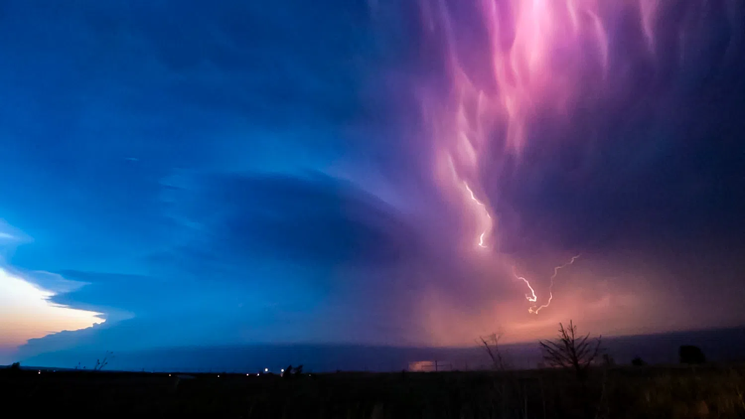
The site to my west was awe inspiring – the wind sculpted updraft of a supercell rising into an anvil cloud that covered everything overhead. Near the surface was the rear flank gust front that merged into the shelf cloud of the rest of the storm complex.
And lightning, seemingly constant lightning, flashing nearly every place of the storm.
I set up my camera to record video once again and was sure I had punched the record button. Between double checking the radar and attempting to get my other camera to focus in the dark, I just let the storm bear down on me.
As if it was an orchestra cueing up a suspenseful score for a tense scene, the tornado sirens in town began to blare and I could hear the tone carried on the wind.
That was the soundtrack as I attempted to locate the rain free base, the area that will give me the best visual cue as to what state the storm is in. But with the fading light and lack of contrast I could not reliably make it out.
The only thing that would give me occasional glances was when the feature was backlit by lightning, which happened only occasionally and never in rhythm.
I could make out what seemed to be the lowering of a wall cloud and I knew a tornado could be ongoing, they don’t need a visible condensation funnel to be in contact with the ground.
I waited as long as I could trying to keep a view of the storm’s base and to report anything that was clearly rotating, but in the darkness it was difficult.
Then I noticed the advancing line of storms to my north was pushing east faster than the base and I was worried my escape route east would soon be swamped with rain and hail.
I decamped from my position and began driving away from McCook. I had thoughts of turning around and continuing to spot, but with darkness having fully fallen, I decided to call the chase and head for home.
Another reason for the decision was that this same line of storms was going to pass over my home in western Buffalo County and given the tornado spin-up threat after dark, I wanted to be there in case that occurred.
As it would turn out, no tornado would occur in McCook and would even be spared from the worst of the hail and wind.
However, it had been a close call.
An EF-1 tornado formed near old Highway 34 west of Trenton and moved to the southeast damaging a few structures, trees and light poles around the football field and track.
A second brief tornado did occur five miles west of McCook, but it remained over open country and was rated EF-0.
While heading east, I was greeted with a sight that seemed oddly juxtapositioned, given the raging storm behind me.
Carrying a dull orange color, the May full moon, known as the Flower Moon, was rising into the night sky. I found it odd the clouds had not covered it up yet, but it seemed to guide my way home.
I didn’t know when I passed through Holdrege on my way home, I would miss another tornado by an hour.
My fear of tornadoes embedded in the line was justified, because an EF-1 would directly impact Holdrege, moving southwest to northeast across a 1.7 mile path. It caused damage to trees and property across the community.
I made it home safely, but I was pacing around like a caged animal, checking the radar and peeking out the windows as the constant lightning allowed for some limited visibility.
There appeared to be an area of mid-level rotation passing to the immediate north of Odessa and I looked out a north window to see what I could see.
A lightning flash illuminated what appeared to be a descending tube for a moment and my heart stopped. But additional flashes revealed this feature to be nothing but a ragged scud cloud.
The brief second of fright was just another reminder of how powerless it feels to be at the whim of Mother Nature.
I had another fright later in the evening when offloading all of my pictures and videos onto my computer. At first glance, I could not locate any video files I took of the approach of the McCook supercell, one of the more awe inspiring sights I have seen as a chaser.
At the moment I was nearly inconsolable with grief. In the heat of the moment had I set up my camera to record, only to forget to hit the button?
After an unhealthy session of intense double guessing, I finally decided to go through the camera’s card, file-by-file. Miraculously, I found the files after all, somehow buried in a section that I didn’t look at the first time.
Looking back on Thursday’s chase, I am grateful I could witness yet another tornado during a 2024 season that has been active with severe weather, to say the least.
The lightning filled approach of the McCook supercell was also a sight I will not soon forget. But my mind also goes to Holdrege being directly impacted by a tornado after dark, the fear I felt for the McCook community, knowing that a tornado could go straight into town.
I always come away from chases with a healthy respect for Mother Nature.
I may go out to witness incredible stormscapes and sights, but knowing that it can be my house or community under the gun next keeps me focused on doing what I can to report the ground truth and helping contribute in whatever little way I can, to helping understand and document severe weather.
Editor’s Note: My name is Brian Neben and this is my sixth year as storm spotter and chaser. I write a personal column about each outing, as it helps to collect my thoughts and I have felt like people enjoy reading about my success or failures perusing this rather niche hobby.